Key Highlights
Here are some important things you should know about the India-Nepal border:
- The India-Nepal border runs for 1,751 km and is an open international boundary found in South Asia.
- People from both countries can move freely across the border. This is because of the 1950 Treaty of Peace and Friendship.
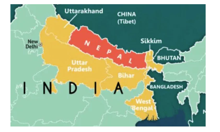
- The border touches five Indian states. These states are Uttarakhand, Uttar Pradesh, Bihar, West Bengal, and Sikkim.
- India and Nepal have close ties, but there are big disputes at the nepal border. A main issue is the Kalapani region.
- There are lots of official check posts set up along the boundary for trade, customs, and safety.
Table of Contents
Introduction
Have you ever thought about how India and Nepal connect with each other? A good way to start is by looking at the border they share. The Nepal border with India is not just a simple line on the map. It is open and shows the strong friendship between the two countries. People from both places can move across it easily because of this setup. But, having an open border also brings some problems for border security. In this article, you will read about the name, map, and history of the nepal border. You will also learn about how the border looks today. This will help you get a clear idea of this area and why it matters.
Overview of the India-Nepal Border
The India-Nepal border is a clear international boundary in South Asia. It goes on for more than 1,751 kilometers. The border area is not only a line between the two countries. It is also a lively place where people from both sides meet for culture and business. This place links many different lands, from the Himalayas to the plains of the Ganges.
Unlike other well-known borders, this one does not have a special or formal name like the “Radcliffe Line.” It is officially known as the India-Nepal border or an open international boundary. This name shows the special and friendly way people in the border region interact. Now, let’s look at where the nepal border is and how it started.
Geographical Span and Length of the Border
This long border starts at the point where three countries meet in the west with China. It then goes toward the southwest. The border moves along many eye-catching land features. These make it a moving and clear line set by nature.
The border goes through the high Himalayas. Then, it moves across the Sivalik Hills, which are covered with trees. After that, it drops down into the large and flat Gangetic plain. A big part of the border’s western side runs with the flow of the Kali River. This river is important because it helps to show where the border is.
There is no special name for it. People just call it the India-Nepal border. The “nepal border” runs for 1,751 kilometers. This line is set by both rivers and mountains. There are also pillars made by people at some spots.
Historical Background and Evolution of the Border Name
The story of the border goes back to the time of the British Raj in India. In the early 1800s, the kingdom of Nepal wanted more land and power. This led to a fight with the British. They had a war called the Anglo-Nepalese War, which happened from 1814 to 1816.
The war ended when the Sugauli Treaty was signed in 1816. The Sugauli Treaty was very important. It forced Nepal to give up a lot of its land to British India. This set up the outline of the border we see now. The border got its modern shape after India became independent in 1947.
The border was set by the Treaty of Sugauli. Later, the 1950 Indo-Nepal Treaty of Peace and Friendship made it the official border for two independent and friendly countries. The name for the border has not really changed. But what the border stands for has changed. It went from being a colonial boundary to being a sign of a special relationship between the two countries.
Official Names and Terminology of the India-Nepal Border
When you search for a real name for the India-Nepal border, you will not find just one title. People call it by what it does and how it works, like an “open international boundary.” These words show what makes the nepal border different from the others.
This line that separates the two countries is respected by both. People on each side of the border call it the Nepal border or the India border. This simple way of naming shows its real purpose and how people use it. We will talk more about this in the next sections.
What is the Recognized Boundary Line Called?
So, what do people call the official line that separates India and Nepal? There is no special one-word name for it. The best way to talk about it is to say “India-Nepal international boundary.” People use this term in all important settings, and they know what it means.
This line is one that both the government of India and the government of Nepal have agreed to. The legal meaning of the boundary comes from deals made in the past. The main one is the 1816 treaty of Sugauli. There have been other agreements after that as well.
The border line does not have a single name. Instead, the side of the border is marked by many things. These things are rivers, tops of hills, and thousands of boundary pillars that stand on the line. Both sides of the border say that these marks are the real split between the two nations.
Changes in Official Naming Over Time
The official name has stayed the same, or sometimes there is not one. But when there are political events, people start to talk about the border in new ways. There is no rule that has changed what the border is called. Still, the talk about the line between the two places can get heated.
A clear example of this happened not long ago when Nepal agreed on a constitutional amendment to bring out a new political map. This map showed lands that people argue about. The main name of the border did not change, but this action showed that Nepal now thinks in a different way about where the border should be.
This expansion drive with maps shows that while the name “India-Nepal border” stays the same, people can still argue about where the line should be. These actions can cause more tension for both countries and make people ask for new talks over the nepal border.
Indian States Sharing a Boundary with Nepal
The long Nepal border is not close to just one part of India. It touches many states of India. Because of this, the border region has strong cultural and economic ties. People who live near the nepal border feel close connections in their daily lives.
There are five Indian states that have a border with Nepal. These are Uttarakhand, Uttar Pradesh, Bihar, West Bengal, and Sikkim. On the Indian side, each state has small towns and people living close to the border. Many places here let people move between the two countries. Let’s look at the main districts next to Nepal from the side of the Indian states west bengal, uttar pradesh, and the others.
List and Map of Bordering Indian States
The India-Nepal boundary goes through five Indian states. Each state adds its own touch to the area with its land and people. The border starts in the Himalayan territories in the west. Then, it moves through busy flat lands and reaches the hills in the east. If you look at a border map, you can see how the land changes as you move across it.
The border starts in the mountains of Uttarakhand, going through the Pithoragarh district of Uttarakhand. It then goes down into the busy plains of Uttar Pradesh and Bihar. After that, it heads east and touches West Bengal before ending in Sikkim.
Here is a quick look at the Indian states that share borders. This also covers some basic things about the line they share.
| Indian State | Key Bordering Area Characteristic |
|---|---|
| Uttarakhand | Mountainous, Himalayan region |
| Uttar Pradesh | Densely populated Gangetic plains |
| Bihar | Major trade and transit points |
| West Bengal | Eastern gateway, near Darjeeling |
| Sikkim | Easternmost point of the border |
Key Border Towns and Districts in Each State
The nepal border has many border towns and districts. These places are key points for trade, travel, and people sharing their way of life. The towns in the border region help connect India and Nepal. They are important for both the economy and the community. You can see the strong links between the two countries in these areas.
These border districts are in five states that sit next to each other. A lot of them are in the Gangetic Plain, which is flat and easy to reach. This helps them grow into busy places for trade across the border and for people to move in and out every day.
Some of the most important border towns that you should know include:
- Raxaul: This entry point is in East Champaran district of Bihar. It is one of the busiest places to cross the border.
- Sonauli: You will find this entry point in Maharajganj district of Uttar Pradesh. A lot of people and goods travel here because it is an important place for tourists and trade.
- Jogbani: Jogbani is in Araria district, Bihar. It joins to Biratnagar, which is a big industrial city in Nepal.
- Panitanki: This crossing is found in Darjeeling district of West Bengal. It is the main entry point on the east side.
- Banbasa: This town is in Champawat district, Uttarakhand. It is an important place to cross the border.
Border Checkposts and Crossing Points
The India-Nepal border is known as an open international border. But it is not completely open all the time. There is a system with checkposts at the nepal border and official crossing points. These are there to help control trade, travel, and safety at the border.
These check posts are important. Some of these are big Indian Integrated Check Posts. They help with checking cargo and doing customs work. They also help people from other countries get visas when they need to visit. Now, let’s look at the major crossing points and the rules for travel.
Major Checkposts and Their Locations
Several major border crossings now have upgraded check posts, called Integrated Check Posts (ICPs). These new places make it easy for people and goods to move, even when there is a lot of traffic or trade. At these check posts, everything gets done in one place, so all cross-border steps are handled simply and fast.
There are many smaller, official border crossings besides the big ones. People in Nepal call these “Chhoti Bhansar” or minor customs. The check posts here mainly help local people and small traders. On each side of the border, local police work to keep things in order and safe at these check posts.
The major border crossings are set up at key spots in the border region.
- Raxaul-Birgunj: People know this place as the ‘Gateway of Nepal’. It is a key route for trade between the two places.
- Sonauli-Belahia: This is a main border crossing in uttar pradesh.
- Jogbani-Biratnagar: This trade point links Bihar to eastern Nepal and is a big trading spot.
- Banbasa-Dodhara Chandani: This is a key ICP found in Uttarakhand.
- Rupaidiha-Nepalganj: This road links Bahraich district in uttar pradesh to the western side of Nepal.
Crossing Rules and Required Travel Documents
Crossing the border between India and Nepal is very easy for people from both countries. This is because there is an open borders policy. Indian nationals and Nepalese nationals can go across the border without showing a passport or a visa. This rule has been in place for a long time and helps both people.
People value the freedom of movement here, and it shows the special connection between both sides. But, you still need documents to cross. You must have a valid ID with you. If you drive your own car, you will have to get a road permit at the border.
Here’s a summary of the required travel documents:
- For Indian and Nepalese Citizens: You need to have a photo ID that is given by the government. This could be your Voter ID card, Aadhar card, or a citizenship card.
- For Personal Vehicles: You must get a road permit from the customs office when you cross.
- For Third-Country Nationals: Bring your passport, and have the visa that you need. Both are a must.
Current Border Issues and Disputed Regions
The border is usually calm and friendly. Still, there are a few old problems that are not yet solved. These fights about territorial integrity sometimes cause tension between the two neighbors, even though most of the time, they get along well.
The most talked-about boundary dispute is about the Kalapani region. There is also another problem over the Susta area. The Government of India and the Government of Nepal both say they have a right to these places. They use old treaties and maps to support what they say. Let’s look at these boundary disputes and see how both countries have tried to solve them with new talks.
Major Disputes Including the Kalapani Region
The main boundary dispute is about the Kalapani region. This land is about 35 square kilometers in size. It is in a key spot where the borders of India, Nepal, and China meet. India takes care of the area as part of India. But Nepal says the Kalapani region should be part of Nepal.
This dispute comes from the different ways people read the 1816 Sugauli Treaty. The treaty named the Kali River as the border. The main issue is where the river starts. Both countries choose a different spot as the source, and that changes where the border falls on the map.
Another place with border issues is Susta. It is on the side of the Gandak River in the south part of Nepal. The trouble started because the river moved over time. When the river changed its path, land that used to be on one side of the border ended up on the other side. This made both sides claim the land.
Recent Developments and Diplomatic Initiatives
There have been some new changes near the border. Things got worse after India opened a new road. This road goes through the Lipulekh pass, which is in the kalapani region that both sides argue about. Right after this, Nepal was quick to speak out and was not happy with India’s move.
Nepal’s government made an important choice when it used a constitutional amendment to back up its claim on some land. It shared a new political map with the disputed areas shown on it. This action was talked about a lot on social media. It also became a top subject in talks between countries.
After this, some diplomatic steps happened. Kathmandu spoke out to share its concerns while New Delhi talked about how the two sides need to sit down and talk.
Both New Delhi and Kathmandu have said that they want to solve this issue through peaceful talks. Leaders, like the External Affairs Minister and other officials, are talking at a high level. Their goal is to lower tensions and find a way that makes the two countries’ bilateral relations stronger.
Nature of Movement and Openness of the Border
The India-Nepal border is known for how open it is. People from both places can move freely across it. This is not common in the world today. This nepal border policy has helped people in both countries feel close and linked to each other.
This rule lets Indian citizens and Nepalese nationals go across the border without needing a visa. This is a right given by the 1950 Indo-Nepal Treaty of Peace and Friendship. Now, let’s look at what is in this treaty of peace about free movement for the people and also talk about the security steps that are used at the same time as this open border.
Free Movement Provisions for Citizens
The idea of free movement is not just a simple practice. The 1950 Treaty of Peace and Friendship makes sure this right is protected by law. This important treaty is the base for the special relationship that India and Nepal share.
This open international border lets indian nationals and nepalese nationals do more than just travel easily. They can also live and work in either place because of this. This has helped many people build lives and find chances for work on both sides of the border.
The main rules that help make this happen are:
- You do not need a visa or a passport to travel across the border.
- People from both countries can live in the other country and look for work.
- Nepalese nationals in India get the same chances for work and study like people from India.
- Every day, many people cross the border for tourism, shopping, and to meet their families.
Customs and Security Practices at the Indo-Nepal Border
An open border does not mean that it is not secure. Both India and Nepal have steps in place to watch what happens in the border area. They keep up border security to stop things that are not legal. This helps manage the flow of people and goods between the two countries.
On the local level, people from both countries often work together. District Magistrates, customs chiefs, and local SSB representatives in India talk with those in Nepal about the security challenges that they both face. The indian side of the border is watched by the Sashastra Seema Bal, and Nepal’s side of the border is under the Armed Police Force. Some of the main things they do for safety are:
- India’s SSB and Nepal’s APF work together for joint border patrols.
- Customs officials and local police control the official crossing points.
- District officials hold regular meetings to help each other on security matters.
- The border is watched closely to stop smuggling, human trafficking, and other crimes that happen across it.
India-Nepal Border on the Map
If you follow the India-Nepal border on a map, you will see it as a winding line. This line goes through some of Asia’s biggest and most amazing land features. It is not a straight, man-made line. The nepal border moves with the shape of the rivers and the mountains.
A clear border map will show that the line starts high in the Himalayas. This is where the kalapani region, which is not agreed on, can be found. After this, the border goes down into the plains. Here, you will see most of the major border crossings that help the two countries connect. Let’s look at some of these important parts.
Important Geographical Features Along the Border
The path of the India-Nepal border goes through some of the most impressive places in South Asia. In many spots, these lands act as the main boundary that marks where the two countries end and start.
The Mahakali River is also called the Kali River. It makes up much of the western border. This river is very important when you talk about the Kalapani dispute. If you move more to the east, the border goes through the Terai region. The Terai region is flat and low, and many people live there.
Other important geographical features include:
- The Himalayan Range: The border starts here in these huge mountains. They act as a strong, natural wall.
- The Sivalik Hills: The border moves through these lower hills as it comes down from the Himalayas.
- The Gangetic Plain: This large flat land shapes the way the border goes in uttar pradesh and Bihar.
- Proximity to Trekking Routes: The border region is close to routes that lead to well-known treks like the everest base camp trek and annapurna base camp.
Locating Popular Border Crossings on the Map
If you look at a map, you will see that the major border crossings touch the important towns. They link key roads on both sides of the Nepal border. This helps people and goods move easily from one place to another. The location of these crossings is no surprise. They are picked to make trade and travel simple on both sides of the border.
Most of the big crossings are in the plains of Uttar Pradesh and Bihar on the Indian side. The land in this border area is very flat. This makes it easy to build roads and other things for heavy traffic and trade. A border map shows these places as the main points for people and goods to move.
Here is where you can find some of the most popular crossings:
- Raxaul (Bihar): Raxaul is right next to Birgunj. The place is a busy spot, and a lot of people cross here.
- Sonauli (Uttar Pradesh): Sonauli sits on the way to Bhairahawa, Nepal. It is the main route for those who want to go to Lumbini.
- Panitanki (West Bengal): Panitanki is in the east and is the main crossing point there. It links up with Kakarbhitta.
- Jogbani (Bihar): Jogbani is close to Biratnagar, which is an important place for trade.
Conclusion
To sum up, knowing about the India-Nepal border is important. It is not only about where the land starts and ends. It also helps you see the history and culture of this area. The border shows the story of both countries, including past events, name changes, and today’s problems. With its special rules, busy towns, and the way people can move freely, the India-Nepal border is a big part of both countries’ lives. If you like to travel, love history, or want to know more about what happens in south asia, learning about the nepal border will help you understand more. If you want to ask anything or need more help, feel free to reach out!
Frequently Asked Questions
Which Indian states share the longest boundary with Nepal?
Among the five Indian states that touch the Nepal border, Uttar Pradesh has the longest one. The border region here has a lot of official crossing points. It is a big place for trade and people from both sides meet here often. It has more trade and exchange than Indian states like West Bengal or Sikkim, which have a shorter border with Nepal.
Are there any document requirements for Indians or Nepalis to cross the border?
Thanks to the 1950 Treaty of Peace and Friendship, indian nationals and nepalese nationals do not need a passport or visa to travel. They do have to bring a government photo ID with them. If you want to use your own car, you need to get a road permit at the border before you go.
Where is the Kalapani border dispute located?
The Kalapani region is a key area in the boundary dispute. It is at the meeting point of India, China, and Nepal. India controls this place as a part of the Pithoragarh district of Uttarakhand. But Nepal’s maps show the Kalapani region as a part of Nepal. This has led to many years of disagreement between the two countries.