Key Highlights
Here is a quick look at the Ganga River System:
- The Ganga River starts at the Gangotri glacier in the Himalayas. At first, people call it the Bhagirathi.
- It flows more than 2,500 kilometers. The river passes through the big Indian states of Uttar Pradesh and West Bengal, then goes out to the Bay of Bengal.
- The wide Ganga basin gets water from many smaller rivers joining in. A major river that joins it is the Yamuna River.
- This river system makes the Ganga Plain. It is a very rich area and helps millions of people for farming and daily life.
- The Ganga is more than just a regular river. It is deeply important for the culture and spirit of people in India.
Introduction
The Ganga River System is a large and important group of rivers in northern and eastern India. The Ganga River, also known as the Ganges River, begins high up in the Himalayas. It moves across the land and helps keep the area full of life. Many people live in this part of the world, and the soil is very good for crops. The Ganga is a significant river. It helps with farming and everyday needs for people. It is also a big part of the culture and beliefs of the country. The ganga river system is truly special to all of us.
Overview of the Ganga River System
The Ganga is one of the three main river systems in the Himalayan Drainage System. This river basin is important for India. The main river in this system is the Ganga. It has a big network of smaller rivers that join it. The Ganga and these tributaries shape the land and help many kinds of living things to survive.
The Ganga basin is spread across many states. It also reaches into some nearby countries. The role of the Ganga is important for the region. It shapes both the land and the culture. The Ganga is still a big part of current affairs. People talk about it a lot because it matters so much, and there are some problems it faces today.
Historical and Cultural Significance of the River Ganga System
The Ganga is special and respected in India, not just for where it is but for what it means to people. The Ganga River has been seen as holy for hundreds of years. Many feel that it is a pure and spiritual river. Every year, millions of people visit its banks. Many cities in Uttar Pradesh that lie along the Ganga are seen as some of the most holy spots for Hindus. The Ganga River System stands as a symbol of faith and hope for so many people.
This deep link between people and the river makes its health very important for the whole country. The river is seen as living. The way people feel inside is connected to how the river is doing. That is why the river has come up again and again in art, books, and religious events for thousands of years.
The government saw how pollution hurts the Ganga, a significant river in India, and started some plans to help. The Ganga Action Plan was one early step to clean up the river. This action plan showed a country-wide promise to keep the Ganga pure and safe, so future generations can know its sacred and cultural stories.
Role of the Ganga River System in India’s Geography
The ganga river system is a big part of India’s geography. It helps shape the land and supports the economy in a big way. One of the most important things about the gawa river system is how it creates the ganga plain. This plain is wide and very rich. The main river and the major tributaries deposit lots of soil here. As a result, the ganga plain has become one of the best areas for farming in the world.
The river system has a very large catchment area. It covers more than 26% of India’s land. This river basin gives water to almost half the people in the country. The river basin goes all the way from the Himalayas to the Bay of Bengal. It also includes parts of the Chotanagpur plateau and helps states such as Uttar Pradesh.
The Ganga is important for people in northern India. Its water helps with watering crops, drinking, and running businesses. The river is at the heart of the economy for this region. The government keeps working on ways to manage the water, which shows how needed the Ganga really is.
Key Features of the River Ganga System
The Ganga River System has some special features that make it stand out. The catchment area is very large. Because of this, the Ganga basin is one of the biggest in the world. It helps many people who live there. The main river in the ganga river system is one of the longest in Asia. The ganga river starts in the Himalayas and goes all the way to the sea.
One important thing about the Ganga is that it has a big network of smaller rivers. These rivers join the Ganga from both the left and right sides. They bring water from many parts of the country. People often put the main tributaries into groups by which side of the Ganga they join.
Key features include:
- Length: The main river goes for more than 2,500 kilometers before it reaches the Bay of Bengal.
- Tributaries: It has many right-bank and left-bank tributaries. Some of the well-known ones are the Yamuna and the Ghaghara.
- Delta Formation: This river, along with the Brahmaputra River, makes the world’s largest delta. This delta is called the Sundarbans.
- Drainage: The whole river basin is very large. It drains an area of over one million square kilometers.
Origin of the Ganga River System
The story of the Ganga River system starts high up in the Himalayas. The main river comes from the Gangotri Glacier in the Uttarkashi district of Uttarakhand. At this place, in the upper reaches, the Ganga river is called the Bhagirathi River. This is where the journey of the Ganga river begins.
This main headstream comes together with another one, the Alaknanda River, at a holy place. When these two rivers meet, it marks the real beginning of the Ganga. The Yamuna River is a big part of this system too. The source of the Yamuna River is in the nearby Yamunotri Glacier.
Glacial Source and Initial Flow of the Ganga River System
The Ganga starts as small mountain streams. These streams get water from big glaciers. The main origin of the river is the Gangotri Glacier. It is found in the Uttarkashi district. The Gangotri Glacier forms the Bhagirathi River. This glacier is very large and looks like a river made of ice. People in India see it as one of the holiest places.
The first movement of water is fast and rough. It cuts through deep valleys in the Himalayas. The Bhagirathi is one of several starting streams of the Ganga. These streams come from ice in the area, and also from the Nepal Himalayas and Himachal Pradesh. The Milam Glacier is another important source. It flows into the Goriganga, which is a tributary of the Sharda River.
Key headstreams and their sources include:
- Bhagirathi River: The Bhagirathi River begins at the Gangotri Glacier.
- Alaknanda River: The Alaknanda River gets its water from the Satopanth and Bhagirath glaciers.
- Dhauliganga River: The Dhauliganga River comes from Vasundhara Tal, which is a big glacial lake.
The Bhagirathi and Alaknanda Confluence Explained
The place where the Bhagirathi and Alaknanda rivers join is very important in the journey of the Ganga. This spot is at a town called Devprayag, which is in Uttarakhand. At this point, the river starts to be called the Ganga. Before this, the rivers that come together each have their own names.
The Alaknanda is a strong river. It gets extra water from several other rivers before it reaches Devprayag. A big river that meets the Alaknanda there is the Mandakini River. The Mandakini River joins the Alaknanda at Rudraprayag. When rivers come together there from the Himalayas, the Ganga gets bigger. This is why the Ganga is so full and powerful.
From Devprayag, the main river goes down to the plains and starts its long path through northern India. On the way, you will see many kinds of land. The river moves from the hills at the edge of the Himalayas and then to flat plains. Not far away, the Kaimur Range runs side by side with the Son River. The Son River is a big tributary of the Ganga river. It joins with the ganga and brings water from its own basin to the main river. The rich areas around the tributary of the Ganga see both mountains and wide plains as the river continues on its way.
Ganga River System Origin: Notes for Quick Reference
The upper reaches of the Ganga have five special spots called the Panch Prayag. Each “Prayag” is a holy place. Here, a tributary of the Ganga river meets one of the main headstreams. These spots are important for people who follow the Ganga river. A lot of people visit these places because they are key for the start of the river. They show how the tributary of the Ganga helps make the river what it is.
Knowing about these five meeting points helps us see where the river begins before it turns into the powerful Ganga. The main river starts from the Gangotri Glacier. It also gets water from other places. All these sources come together through these important meeting points.
Here is a quick reference table for the Panch Prayag and the river system at each place:
| Place of Confluence | River System |
|---|---|
| Devprayag | Bhagirathi and Alaknanda |
| Rudraprayag | Mandakini and Alaknanda |
| Nandaprayag | Nandakini and Alaknanda |
| Karnaprayag | Pindar and Alaknanda |
| Vishnuprayag | Dhauliganga and Alaknanda |
Course and Drainage Pattern of the Ganga River System
The Ganga River System takes a long and winding path. This journey shapes the land in northern India. The main river leaves the mountains and then moves across the flat Ganga plain. Its way is shaped by the land being flat and by the sediment the river picks up and carries with it. The Ganga basin has a drainage pattern that looks like a tree with many branches. This is how the Ganga river makes its mark on this area.
This pattern happens when the main tributaries join the main river at different places along its course. If you know about this flow and pattern, you can see just how big the river basin is.
The Path of River Ganga System from Himalayas to Bay of Bengal
The Ganga river starts in the Uttarkashi district of Uttarakhand in the Himalayas. The main river comes down from its glacial source to the plains at Haridwar. At this point, it moves in a straight line and travels south and then southeast. The river crosses the big Ganga Plain as it flows on its way to the mouth.
The river flows through many places, like Uttar Pradesh and Bihar. It picks up water from many small streams along the way. When the river gets close to West Bengal, it moves slower. It starts to drop the heavy silt that it brought down from the hills. This dropped silt is the reason the flat land in this area turned into good, rich soil over many years.
Near the coast of West Bengal, the river divides into many smaller streams. The biggest one, called the Padma in Bangladesh, moves to the east. Another main branch, the Hooghly, goes south and passes through Kolkata. This river system reaches the Bay of Bengal. It makes the largest delta in the world.
Drainage Patterns in the Ganga River Systems
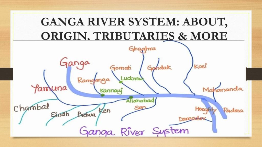
The drainage pattern of the ganga river system is called dendritic. This name comes from a Greek word that means tree. The pattern looks just like a tree. The main river is like the trunk. The tributaries of the ganga river spread out like the branches. You can see how the ganga river system looks simple but works well. All the parts of the river system join together, just like the branches join the trunk of a tree.
This pattern happens in places where the rock under the ground does not really affect how the river moves. The Ganga basin is mostly flat and even. Tributaries can join the main river from any side in this area. This forms a big network with lots of branches. In the upper reaches, which are in the Himalayas, the land is rough. Here, the river’s route is shaped more by the way the mountains are formed.
Key characteristics of this drainage pattern include:
- A tree shape forms with branches as you look at it.
- Small rivers join the main river at sharp angles.
- The network goes out far over the wide river basin.
- You see both right-bank and left-bank tributaries in it.
- This shape helps to drain the big catchment area well.
Important States Traversed by the Ganga River System
The Ganga River starts in the Uttarkashi district of Uttarakhand. Here, you can find its headwaters. From this place, the Ganga moves down from the mountains and goes into the plains. On its way, the river passes through five Indian states. One of these states is Uttar Pradesh. In Uttar Pradesh, the Ganga River travels the longest distance from all the states it flows through.
After the ganga river passes through uttar pradesh, it goes into bihar and then crosses a small area in jharkhand. The last state where the main river goes is west bengal. Here, it starts to make its delta. The main river travels through these five states. The ganga river basin, however, stretches across a bigger place than what the main river does.
The basin’s catchment area covers places in 11 states. These states include Haryana, Rajasthan, Madhya Pradesh, and Himachal Pradesh. Delhi is also part of this area. The river system is not limited to India. Some parts of the basin reach past the border and go into Nepal. Nepal adds a lot of water to the basin from smaller rivers that start close to the Nepal border.
Major Tributaries of the Ganga River System
The Ganga is so big because many major tributaries flow into it. People call these tributaries either right-bank or left-bank. This depends on which side the tributary joins the main river as it moves downstream. Most left-bank tributaries start in the Himalayas. The right-bank ones often start from the peninsular plateau.
Key tributaries such as the Ramganga River, Ghaghara River, and Kosi River join the Ganga River from the left side. The Yamuna and Son River are the major right-bank tributaries. All these rivers come together to make up the large Ganga river basin.
Main Right-Bank Tributaries of the Ganga River System
The right-bank tributaries of the Ganga come mostly from the peninsular plateau in the south. The most important tributary of the Ganga on this side is the Yamuna River. The Yamuna River is also a big river by itself. It runs for a long time next to the Ganga before both rivers join together at Prayagraj.
Another big right-bank tributary of the Ganga is the Son River. The Son River starts in the Amarkantak Plateau. It goes north and joins the Ganga near Patna. The Chambal River is famous for its badland topography. The Chambal River is a tributary of the Yamuna, but it is also an important part of the Ganga system.
The main right-bank tributaries include:
- Yamuna River: This is the largest tributary when it comes to volume. The river begins at the Yamunotri Glacier.
- Son River: A big tributary from the south. It starts at the Amarkantak Plateau in Madhya Pradesh.
- Chambal River: The river flows from the Malwa Plateau and meets the Yamuna River.
Main Left-Bank Tributaries of the Ganga River System
The left-bank tributaries of the Ganga mostly start in the Himalayas. These rivers hold a large amount of water, mainly in the monsoon time. The water from these rivers carries the sediment that helps to make the land along the Ganga rich and good for farming. A big tributary of the Ganga is the Ghaghara River. The Ghaghara River begins on the Tibetan plateau and is an important tributary of the Ganga.
The Gomti River begins in a lake in the plains of Uttar Pradesh. It then moves ahead on its way and joins the Ganga after Varanasi. The Kosi River is known for its many floods. People even call it the “Sorrow of Bihar.” It brings a lot of silt from the Himalayas. The Damodar River goes through the Chotanagpur Plateau. Later, it joins the Hooghly in West Bengal.
Prominent left-bank tributaries are:
- Ramganga River: The Ramganga River meets the Ganga close to Kannauj in Uttar Pradesh.
- Ghaghara River: The Ghaghara River is a big river that starts near Lake Mansarovar.
- Kosi River: The Kosi River is called the Saptakoshi because it has seven main tributaries that come from the Himalayas.
List of Key Tributaries of the River Ganga System Notes
To see how the Ganga river system works, it is good to check the main tributaries of the river. There are several rivers, both big and small, that flow into the Ganga river and help form the Ganga basin. These main tributaries are called either right-bank tributaries or left-bank tributaries. This helps us better know how the river system of the Ganga is organized.
This way of sorting helps you learn about the geography of the river basin. Most left-bank rivers come from the Himalayas. Right-bank rivers start from the central Indian highlands. Rivers like the Tamur Kosi belong to the bigger Kosi system. The Gomti starts at Fulhaar Jheel.
Here is a table of some important tributaries of the Ganga river:
| Tributary | Bank | Origin/Key Fact |
|---|---|---|
| Yamuna | Right Bank | Yamunotri Glacier |
| Son | Right Bank | Amarkantak Plateau |
| North Koel | Right Bank | Tributary of the Son river |
| Ramganga | Left Bank | Dudhatoli Hill, Uttarakhand |
| Gomti | Left Bank | Gomat Taal (Fulhaar Jheel) |
| Ghaghara | Left Bank | Glaciers of Mapchachungo |
| Gandak | Left Bank | Nepal Himalayas |
| Chhoti Gandak | Left Bank | Tributary of the Ghaghara |
| Kosi | Left Bank | Confluence of Sun Kosi, Arun Kosi, and Tamur Kosi |
The Ganga river is made up of several tributaries. The right bank tributaries of the Ganga river include the Yamuna, Son, and North Koel. Yamuna comes from the Yamunotri Glacier. The Son river starts at the Amarkantak Plateau. The North Koel is a tributary of the Son river.
Several tributaries of the Ganga river are on the left bank. Ramganga starts from Dudhatoli Hill
Cities and Regions Along the Ganga River System
The Ganga River System goes through many of India’s most crowded areas. The main river and its major tributaries offer water and good land for farming in the Ganga basin. Because of this, people have built big cities along the Ganga River and its major tributaries for many years. The fertile ground and water from the river system help many people in the area. The Ganga and its river system play an important role in both city life and farming along the river banks.
These important cities and farming areas need the river system for water to drink, farming, and moving goods. The health of the river system is key for the local economy and keeping things going well for everyone.
Prominent Urban Centers on the River Ganga System
Yes, there are some big cities on the banks of the Ganga river. A few of India’s oldest and most important places are on the sides of this river. In the upper reaches, Rishikesh and Haridwar stand out as top spots. A lot of people go there for both visits and prayers. As the Ganga river goes down into the flat lands, it runs by large cities that focus on both work and culture.
In Uttar Pradesh, the Ganga goes through Kannauj, Kanpur, Prayagraj (Allahabad), and Varanasi. People in each city feel a strong tie to the river. Varanasi is one of the world’s oldest cities, and many call it a main spiritual place. After these cities, the Ganga heads on and moves through Patna and Bhagalpur in Bihar.
In West Bengal, the Hooghly distributary runs across Kolkata. This city is known for being a huge metropolitan area and is also an economic hub. A lot of people live in these cities. The high number of people has put extra pressure on the river. Now, the river faces pollution problems. The Ganga Action Plan is one action plan that tries to solve these challenges with the Ganga in mind.
Agricultural Regions Benefiting from the River System Ganga
The Ganga River System is very important for farming in India. The fertile land in the Ganga Plain comes from soil that the main river and its major tributaries bring in. This makes the Ganga Plain a great place to grow crops. The area produces a lot of the food grains for the country. The ganga helps the people who live in and work on the land, giving them what they need to grow food for us all.
The river basin has lots of water resources. People use these for farming by building many canals. This helps crops grow even when it is dry. The good water supply means that fields can be watered all through the year. Farmers can plant different crops for more than one season. With enough water in the river basin, they can grow rice and sugarcane, which need a lot of water.
Agricultural help from the river system includes:
- Rivers give water for crops. This helps farms grow more food to feed people and animals.
- A river system is good for the soil. Water from the river adds nutrients, which makes the land rich and good for planting.
- A river system lets farmers use irrigation. This means they can bring water right to their plants, even when there’s no rain.
- A river system supports fishing. People can catch fish to eat or sell, so it can help families earn money.
- Fertile Soil: There is always new silt added to the land. This helps the soil be rich for crops.
- Irrigation: A big network of canals gives water to the fields so crops can grow.
- Groundwater Recharge: The river system helps keep the ground water high.
- Diverse Cultivation: A wide range of crops grows here. You will find wheat, rice, pulses, and oilseeds in the fields.
Conclusion
The Ganga River System is more than just a beautiful part of nature. It acts as a lifeline for India and shapes its people, land, and ways of life. The Ganga begins its journey in the Himalayas and moves all the way to the Bay of Bengal. As the river flows, it carries with it stories of the past, what people believe in, and how they live each day.
When you look at the ganga river and see the places and cities it passes, you start to see just how much it means to all of us. It is not only about water. The river system plays a big role in the environment and for so many people along its banks. There is so much to know about how these tributaries join to keep things going and help the land.
Thinking about the ganga river system reminds us that we should look after it, so it stays healthy and beautiful for future generations. If you want to learn more or join in on this topic, feel free to read more or talk with us.
Frequently Asked Questions
What are the major left-bank tributaries of the Ganga river?
The main left-bank tributaries of the Ganga river come from the Himalayas. These rivers are the Ramganga, Gomti River, Ghaghara River, Gandak, and Kosi River. Each one adds a lot of water and sediment to the Ganga river. This helps make the northern plains rich and good for farming. The tributaries of the Ganga river are important for the land and the people that live in this area.
Which states does the Ganga river flow through in India?
The Ganga river flows through five Indian states. It starts in the Uttarkashi district of Uttarakhand. Then, it goes to Uttar Pradesh, Bihar, and a small area of Jharkhand. After that, it enters West Bengal. The main river moves through these states. The larger area, called the basin, also covers parts of Madhya Pradesh and a few other places. The Ganga has a big role in these parts of India.
Where does the Ganga river meet the ocean?
The Ganga River meets the ocean at the Bay of Bengal. The main river slows down as it gets closer to the sea. In West Bengal, it splits into many smaller rivers. These make up the big Ganga-Brahmaputra Delta. The river flows to the Bay of Bengal near Sagar Island. This is where the main river finishes its long trip from the Himalayas.