Key Highlights
- India is known for its wide river systems, which are sorted into two main groups: Himalayan rivers and Peninsular rivers.
- The rivers of India are very important for culture and for the economy. These rivers help farmers and support millions of people.
- PDF maps are helpful if you are a student or someone preparing for exams like UPSC.
- The maps show the major rivers of India, river systems, tributaries, starting points, and the names of cities found beside them.
- You can find good maps of Indian river systems from places like NCERT and several government websites.
- It is key to know about the way Himalayan rivers and Peninsular rivers flow and the special things about them when you are trying to learn more about geography.
Introduction
The rivers of India are very important for the country. They are not only part of the land but also the country’s lifelines. These rivers have deep cultural significance. People use the rivers in their daily life. Rivers also help the economy and have a strong place in spirituality for many people.
There are both himalayan rivers and peninsular rivers in India. These rivers make a network over the places and support farming, help the animals and plants, and carry the long history of the land. All in all, the rivers of india have a crucial role in keeping the country going. Have you ever thought about how these water bodies shape life in India?
Overview of Indian River Systems
India has many river systems that shape the land and way of life in the country. Every Indian river has its own path. These rivers play a significant role by making the plains rich and helping several types of plants and animals to live and grow. Their water is also important for farming and the economy.
These systems fall into two main groups. One group is the Himalayan rivers, and the other is the Peninsular rivers. Both of them are very important, but they are not the same. They begin from different places, move in their own ways, and affect the land in different ways too. Now, let’s talk more about the Himalayan rivers and Peninsular rivers, and why they matter.
Major Classifications: Himalayan and Peninsular Rivers
The Himalayan rivers begin high up in the snow-covered mountains and glaciers in north India. Some of these rivers are the Ganga and Brahmaputra. They always have water because they get it from melting ice and rainfall all year. The rivers in this area travel for a long distance across flat lands. They are an important source of water for farming and travel.
The peninsular rivers are in South India. These rivers are mainly fed by rain. Rivers such as the Godavari, Krishna, and Kaveri start in the Western Ghats or the central highlands. The flow of these rivers depends on the monsoon, so they do not always have water. In most years, they can be dry at some times. The courses of these rivers are shorter and not as deep as the rivers that come from the Himalayas.
Many PDF maps that you can download make it easy for you to see the difference between Himalayan rivers and peninsular rivers. A lot of these maps use colors or special lines for each group. It helps you look at both river systems and see just how they flow across India. These study aids are good for anyone who wants to learn about how drainage works in the country.
Importance of Rivers in India’s Geography
The river systems in India are very important to the country. They give the water that farmers need to grow crops and farms. This is the backbone of the Indian economy. The land made rich by river deposits, mainly in the Indo-Gangetic basin, helps people grow many crops. These plains are some of the most farmed places in the world.
These rivers help with more than just farming. People use them for traveling, to make hydroelectric power, and to get drinking water in many cities and villages. The volume of water in the rivers rises a lot during the monsoon season. This helps fill up groundwater. It also keeps the ecosystems in the area healthy and supports many kinds of plants and animals.
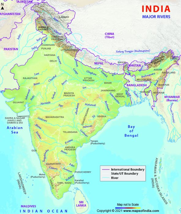
A river map PDF shows the major rivers of India like the Ganga, Brahmaputra, Indus, Godavari, Krishna, Narmada, and Mahanadi. It also points out their main tributaries. With this map, people can get a good look at the country’s rivers of India, their places, and see how these major rivers are an important part of its cultural heritage and land.
Key Features of Map of India Rivers PDF
A map of India’s rivers in PDF form is a good tool for people who want to know about the country’s land and water. The maps show the river systems with clear and simple images. You can see how the major rivers move through India and how they fit in with the land around them. A map of India like this helps people understand where the rivers go and how they work with the other parts of the land.
With a good Indian river map, you can see how each river flows from where it starts to where it ends. This helps you learn about the land, the history, and how people make money in different parts of the country. An Indian river map makes these things easy to understand.
What Does a Detailed Indian Rivers Map Include?
A detailed map showing the rivers of India is more than just a bunch of lines. It helps you see where all the rivers are in the country. You can use the map to see how the rivers connect and flow across India. These maps are easy to read, so you get the information fast. They make it simple to learn about all the rivers of India and understand how they shape the land.
What do you see on a map like this? A good map shows some main things:
- Major Rivers: There are clear labels on all big rivers like the Ganga, Indus, and Godavari.
- Tributary Systems: The smaller rivers and streams that flow into the main rivers are shown.
- Source of Water: Glaciers, lakes, or high places where the rivers begin are marked.
- Flow Direction: Arrows show which way the rivers go.
- Major Cities: The map shows where the big cities are along the river banks.
If you want a simple look at river systems in India, you can get an outline map of India in PDF. This map shows the main rivers. It is good for practice and helps with basic learning.
Benefits of Using Indian Rivers Map PDF for Study
Using an Indian rivers map in PDF form has many benefits, especially when you are studying or getting ready for exams. A PDF map can be had on the phone, tablet, or computer, so you can read it wherever you go. You can zoom in on any part of the map to see more about the rivers and their location.
These maps help students a lot when they study for exams like the UPSC. Geography is a very important part of these tests. The maps make it easier to remember where the sacred rivers are. You can also see the path of the river Godavari and its tributaries. The pictures in the maps help you learn better than just reading about them.
Yes, you can find lots of Indian rivers maps made for the UPSC exam. Most of these are available as PDF files. They focus on what you have to study for the exam. The maps show important things you need to know such as:
- Some big hydroelectric projects are there.
- There are important pilgrimage sites on the banks of the rivers.
- The river systems help in setting up economic zones.
Downloadable PDF Maps for UPSC and Academic Use
For students who are getting ready for the UPSC exam or who study geography, having a downloadable map of the rivers of india is very helpful. A map like this shows where the river systems are, and it lets you see how they connect with each other. It helps you answer map questions in tests, and be sure about regional development too. A clear picture of the rivers of india makes learning easier and gives people a better way to understand the topic.
Having a good Indian river map in PDF is helpful. It makes exam study easier by keeping the main river details in one spot. Let’s see where you can get these useful maps.
Where to Find High-Quality Indian Rivers Map PDFs
Finding top maps showing the rivers of India can be simple. There are many trusted websites that let you get these maps for free. A key thing is to use the right sites, so you have maps that are true and from this year. This way, you get good info and up-to-date maps about the rivers of India.
For exams and studies, it is good to use official and educational sources. These groups offer maps that are checked for facts. High-quality Indian rivers maps in PDF format are found mostly on government and school websites.
Here are some good places to start looking:
- NCERT Website: You can find maps in the geography textbooks and other resources on this site.
- Survey of India: This is the main mapping agency for the country. [Source: https://www.surveyofindia.gov.in/]
- Government Portals: Websites from ministries such as the Ministry of Jal Shakti have many hydrological maps.
- Educational Websites: A lot of online platforms that help people get ready for exams also share helpful maps.
NCERT and Government Sources for Drainage Maps
NCERT (National Council of Educational Research and Training) gives teachers and students good materials for learning. You can find drainage maps there. These maps are used in their geography lessons. They help you get to know river systems in India in an easy way. The maps show how rivers flow and connect. This makes it clear for people to learn about river systems in the country.
Yes, NCERT gives PDF maps that show the drainage system and rivers in India. These maps are part of their textbooks. Anyone can download them for free from the NCERT website. They are made to help students. You can find all the major river basins on these maps. The maps point out both Himalayan and peninsular rivers and show how they are not the same.
Government sources are also a good place to get maps that are right. Here is why these sources are important:
- Accuracy: Government-made maps use real surveys, so the data is usually correct.
- Detail: These maps give a lot of facts about river basins, how water moves, and water sources.
- Credibility: Data from the Central Water Commission is trusted. Many people use their maps for school and research work. [Source: https://cwc.gov.in/maps]
The Ten Longest Rivers in India
India has some of the top rivers in the world. To know the longest rivers of India is important when you want to learn the geography of the country. The Ganga River is sacred, and the Indus River is full of history. These rivers have helped shape people, places, and way of life in India over many years.
This part will help you know about the ten longest rivers found in the Indian subcontinent. You will see where these longest rivers start, how long they are, and which states they move through. This will give you a simple idea of how far and wide these rivers go.
Table: Origin, Length, and Major States Traversed
To get to know the longest rivers in India well, it helps to look at the main facts in a clear way. A river’s starting point, its total length, and the big states it goes through are the important things that students and people who love geography need to know.
The table here shows the top 10 longest rivers in India. Use this information when you study for exams or if you want to learn more about river systems in the country. The list can help you get to know which river is longest and how the river systems work in India.
| River | Origin | Length in India (km) | Major States Traversed |
|---|---|---|---|
| Ganga | Gangotri Glacier | 2525 | Uttarakhand, Uttar Pradesh, Bihar, West Bengal |
| Godavari | Trimbakeshwar | 1464 | Maharashtra, Telangana, Andhra Pradesh, Chhattisgarh |
| Krishna | Western Ghats | 1400 | Maharashtra, Karnataka, Telangana, Andhra Pradesh |
| Yamuna | Yamunotri Glacier | 1376 | Uttarakhand, Himachal Pradesh, Delhi, Haryana, Uttar Pradesh |
| Narmada | Amarkantak Plateau | 1312 | Madhya Pradesh, Maharashtra, Gujarat |
| Indus | Mansarovar Lake | 1114 | Ladakh |
| Brahmaputra | Angsi Glacier | 916 | Arunachal Pradesh, Assam |
| Mahanadi | Sihawa | 890 | Chhattisgarh, Odisha |
| Kaveri | Talakaveri | 800 | Karnataka, Tamil Nadu |
| Tapti | Multai | 724 | Madhya Pradesh, Maharashtra, Gujarat |
How Indian River Maps Mark the Longest Rivers
Indian river maps use certain signs so you can see which are the longest rivers and why they matter. These tricks make it easy for people to get info fast and without confusion. A map may draw the Ganga River, Brahmaputra River, and Indus River with big, bold lines. This shows that these rivers are important and also that they stand out over the rest. It helps you pick out the longest rivers on any Indian river map.
Detailed river maps in PDF show all the big rivers of India. These maps give extra focus to the longest rivers. This helps people quickly spot the major waterways that shape the geography of the country.
Here are some common ways maps show these rivers:
- Bold Labeling: The names of major rivers are in bold letters or bigger print. This helps you see them clearly.
- Color Coding: The river basins may be shaded with different colors. This is used to help you know which areas have certain rivers.
- Line Thickness: The width of the line that shows the river can let you know how long or big it is.
- Symbols: There are icons to mark major cities, big dams, and places where rivers join. This is done to make the map easy to read.
Origins and Tributaries on Indian Rivers Map PDFs
A river map gives you more than just the route a river takes. It shows you where the river starts, like the gangotri glacier or mansarovar lake. The map will also show the small streams and the other rivers that join it along the way. If you know where the river begins, it helps you learn more about what makes this river what it is.
PDF maps are a good tool for looking at these details. You can see the exact source of the river on the map and follow the many smaller rivers that flow into the main one. The Yamuna begins at the Yamunotri Glacier and is joined by several tributaries. The Godavari, called “Dakshin Ganga,” also gets water from numerous tributaries.
Source Locations Marked on the Map
The origin of a river is an important part of knowing about that place. Good maps are made to show where rivers start. If you look at maps of Himalayan rivers, you will see that sources are marked. For example, the Yamuna starts from the Yamunotri Glacier and the Ganga starts from the Gangotri Glacier. There are other rivers like the Indus and the Brahmaputra. These rivers start from the big area near the Mansarovar Lake in Tibet.
For rivers in the peninsula, the maps will show where they start. These source points are often in places like the Western Ghats or highlands such as the Amarkantak Plateau. By looking at this visual information, you can link the river’s features to where it begins. This is true if it is a Himalayan river that flows all year or a Peninsular river that is seasonal. You can see how the western ghats and other places affect peninsular rivers from their source.
Yes, there are a lot of PDF maps that show the origins and tributaries of important Indian rivers. These maps are good for students, as they help students see the whole river system. You can see where a river starts and learn about its path all the way to the sea.
Major Tributary Systems for Top Rivers
The power of a big river comes from the numerous tributaries that flow into it. These smaller rivers add water to the main channel. They also help the river basin cover a large area. Maps that show these systems of numerous tributaries are important for understanding India’s hydrology.
For example, the Ganga starts from the Gangotri Glacier. It forms when the River Alaknanda and Bhagirathi come together. The Ganga gets water from many major tributaries. These include the Yamuna River, Ghaghara, and Kosi. The Yamuna River also has some big rivers that flow into it. The main ones are the Chambal and Betwa. A good map will show all these links between the rivers in a clear way.
PDF maps made for close study show these river networks clearly. They let you follow each big branch and see where it joins the main river. This helps you picture the whole river system and see how much these waterways connect with each other.
Cities Located Along Major Indian Rivers
All through time, many major cities have grown beside rivers. River systems often gave people water, food, and a way to travel. These places let people build good lives and grow. In India, this close link can be seen easy in the many major cities that sit along rivers such as the Ganga, Yamuna, and River Godavari.
The land near rivers like the Kaveri is often called the “Garden of Southern India.” This place is good for farming and has helped many people live there for a long time. The area is also known for its strong cultural heritage. When you look at maps, you can see how the towns and cities in southern India are close to these rivers. The map shows that these urban centers grew up next to river routes, which helped them get water and grow food.
Map Indications of Urban Centers on River Banks
Detailed river maps give you more than just a look at the rivers. These maps also show you the major cities found along the banks. The cities be marked with dots or different symbols. Their names also be written next to them. This way, you can see how people live close to rivers and how the cities depend on water sources.
By looking at a map, you can see where rivers go and find major cities. Delhi is on the Yamuna. Varanasi is on the Ganga. Nashik is on the Godavari. This helps people know the way trade went long ago. It shows how culture spread over time. You also learn why the top places for religious rituals are found there.
You can get a PDF with cities on the major rivers of India from several sites on the web. Many educational websites, government sites, and online maps show you how these cities sit on the river systems. These maps are good to use when you want to read, study, or do more research about the major rivers of India.
Relationship Between River Routes and Indian Cities
The link between river routes and where major cities in India are found goes far back in time. Rivers were used for trade and travel. These water paths made it easy for people to move goods and share ideas. This is why many big business centers grew up along the rivers.
Many cities grew up next to rivers because there was fresh water there for people and for farming. Rivers also mean a lot in the culture of these cities. A lot of towns started to be near pilgrimage sites, which are special places where people travel for spiritual reasons. Cities like Haridwar, Allahabad (Prayagraj), and Varanasi show how strong this connection to rivers and pilgrimage sites is. The cultural significance of these spots helped shape these famous urban centers.
PDF maps that show cities along river routes are easy to find. A short search on learning sites or government pages like the National Portal of India will give you detailed maps. These maps show how the rivers and the cities across India are linked by history.
Differentiating Himalayan and Peninsular Rivers on the Map
One important skill in learning about Indian geography is knowing how to tell the difference between river systems like the Himalayan rivers and the peninsular rivers. These two river systems have their own traits and you can see these differences clearly on a map. The Himalayan rivers are found mostly in the north. The rivers of peninsular India shape life and the land in southern India.
Knowing about these differences helps you see the changes across the country. The land goes from strong northern plains to rich deltas found in the “Garden of Southern India.” A map shows how you can spot these places and understand southern India better.
Distinct Features Visible in Map of India Rivers PDF
A good map of India that shows river systems helps you see the differences between the two big groups of rivers. When you look at this map, you can spot where the rivers start, the way they move, and the direction they go. This makes it easy for people to tell the two river systems apart.
Most peninsular rivers, like Mahanadi, river godavari, Krishna, and Kaveri, start in the western ghats. They all flow in an eastward direction and end up in the bay of bengal. But only a few rivers, such as Narmada and Tapti, go in the other way and flow west into the arabian sea. Himalayan rivers begin in the high northern hills. These rivers travel across the plains as they move ahead.
Many maps show clear differences between these things. Here are some features you might notice:
- Color-Coded Basins: The map uses different colors to show the river basins in the Himalayan area and in the Peninsular region.
- Origin Labels: It clearly marks where rivers start in the Himalayas and where they begin at the western ghats.
- Flow Patterns: The map shows how rivers in the Himalayas branch out, while peninsular rivers follow straighter paths.
- River Labels: On some maps, labels like ‘(P)’ for peninsular rivers or ‘(H)’ for rivers from the Himalayas let people know which river is which.
Educational Uses for Students and Exam Preparation
For students, and those getting ready for exams like UPSC, it is very important to know the ways river systems are different from each other. This is not only about learning in school. You need to know these things. A map helps a lot. It can take river systems from ideas on a page, and show them in a way that’s easy to see and understand. A map changes something you read about in books into something real that you can look at.
It is important to know how to find major rivers and tell them apart in geography. Many geography questions will ask you to do this. A picture or chart can help you remember the names. This also makes it easy to go over these hard topics fast.
Yes, there are a lot of Indian rivers maps in PDF made just for UPSC exam help. These files be great for you when you want to study. The maps help you in these ways:
- Try to see and remember where the rivers are and how they flow.
- Do some practice with pointing to places on the map.
- Get to know the area and land around each river system.
- Look at peninsular rivers and Himalayan rivers. Try to see how they are the same and different.
Conclusion
Learning about the network of rivers in India is important for people who want to know more about geography or study for exams. The Indian Rivers Map PDF is a great tool. It gives clear information about the river systems, where the rivers start, and the cities they flow through. This map helps you see important facts about rivers and can make studying easier, especially for exams like the UPSC. You can find high-quality PDFs from trusted sources to help you understand more about river systems in India and why they matter for the country. If you want to make your study better, get a top Indian Rivers Map PDF now.
Frequently Asked Questions
Can I get a printable Indian rivers map PDF for geography projects?
You can find many printable PDF maps of the rivers of India online. There are something on government portals and educational websites. These let you get high-quality maps of Indian river systems. The maps help students with their geography work, projects, and studies. If you search for “printable Indian river map PDF,” you get lots of options to choose from. You can use them to learn more about the rivers of India and their river systems.
Does NCERT provide a PDF map of the drainage system and rivers in India?
Yes, NCERT has drainage maps that show the river systems of India in their geography textbooks. You can find these maps in PDF files on the NCERT website. The maps are a good resource for learning and school work. They help you see the major rivers of India and understand river systems. Many students use these maps to study about the rivers of India and major rivers in our country. These maps be really helpful for all who want to know more about India’s river systems.
Are detailed city locations and tributaries included in Indian rivers map PDFs?
Most good Indian rivers map PDFs give simple details about big cities and the streams that join the major rivers. These maps show how smaller rivers connect to big rivers like the ganga river and river godavari. They also mark where the major cities are beside these rivers.